A Travel Guide to Agulhas National Park
Access
Agulhas National Park is situated 210 kilometres (130.2 miles) from Cape Town. Tourists wanting to visit the nature reserve can travel along the N2 highway towards Port Elizabeth and then take the Caledon off ramp and pass through Bredasdorp.
The gates to the national park are open between 07h00 and 19h00 and guests will need to pay an entry fee to access the reserve.
Airport
Visitors can fly in to Cape Town international airport and then take an easy 2 hour drive to the reserve.
Highlights
Cape Agulhas is southernmost tip of Africa and the meeting points for the Indian and Atlantic oceans. Dramatic rugged coastline and scenery await and the area is considered one of the richest for plant diversity, for its size, in the world. Birdwatchers will enjoy the excellent coastal, wetland and heath bird watching and walkers and hikers can set out on a number of trails within the reserve.
Activities
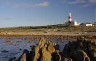
A photograph at the cairn that marks the southernmost point's exact location is a must-do while in the area. The nearby lighthouse and museum offers interesting insight into the area and the history of lighthouses. Seventy-one spiralling steps take one breathlessly up to the top of the lighthouse where beautiful views out across the ocean and surrounding area await. The lighthouse is the second oldest working lighthouse in South Africa. Looking out towards the east, across the shore one will notice the remains of the Khoisan people's ancient stone fish traps.
The area is also full of shipwrecks and the remains of the Meisho Maru 38 wreck can still be seen along the stores. Fishermen can obtain a permit from the Struisbaai Post Office and deep sea fishing is a popular past time for visitors and locals alike.
Accommodation
There are a number of guest houses, B&B's, self-catering houses available to rent in the L'Agulhas and Struisbaai areas. See Agulhas National Park accommodation
The Experience
Cape Agulhas sits on a relatively unspoilt stretch of coastline with beautiful scenery and wide open spaces. There isn't that much to do in the reserve but a visit is definitely worth it for the beautiful setting and the opportunity to see the lighthouse and where the tip is located. A great way to spend a day while on route to the Garden Route or down to the Cape.
Climate
The nature reserve is considered one of the windiest areas in South Africa with the westerly wind pumping in winter and the easterly wind in summer. Wind speeds can reach to over 35km/h (21.7 miles/h). The area is situated in a winter rainfall area with most of the rain occurring between May and October and heavy mist is common in autumn and winter.
Average temperatures are mild, and can be quite chilly when the wind is blowing near the coast. The average temperatures in summer range from 25°C (77°F) to 27°C (80.6°F) and dropping to just over 7°C (44.6°F) in the winter months. The waters are also mild to cold and temperatures range from 21°C (69.8°F) in summer to 14°C (57.2°F) in winter.
Useful Information
The currents and tides can be very strong and dangerous, especially inshore and swimmers are advised to not go too far from the shoreline. The weather extremes and sudden changes occur regularly and suddenly and hikers are advised to always be prepared. The ecosystem in the area is very fragile and hikers and walkers are asked to always stay on the demarcated trails.

 When you visit Agulhas National Park you'll be at the southern tip of Africa – the Cape of Storms. This beautiful Western Cape Nature Rese...
 Located on the southernmost tip of Africa where the Atlantic and the Indian oceans meet, the Cape Agulhas National Park has jagged landscape...