In the Royal Natal National Park, Drakensberg, KwaZulu-Natal, South Africa visitors can appreciate the ever changing hues and moods of the Amphitheatre and gaze on the Tugela Falls.
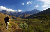
In Royal Natal National Park, Mont-aux-Sources - the highest peak of the plateau - is a source of KwaZulu-Natal's largest river and highest waterfall, the Tugela, and eight other rivers. This beautiful nature reserve in the Drakensberg, KwaZulu-Natal, South Africa is one of the most popular for outstanding views, walks and hikes.
The Tugela Falls, one of the highest waterfalls in the world, plunges down the mountain side in five clear leaps. After heavy rains, up to 18 waterfalls appear along the Amphitheatre. Often covered in snow in winter, the upper Tugela Falls can freeze to form pillars of ice, a delightful and rare sight to be relished.
Guests at this nature reserve can discover the network of trails that cover this part of the Drakensberg, KwaZulu-Natal, South Africa. A comprehensive guide for hikers and trailists is available from the reception office of Thendela Camp.
Please note: Weather and hiking in the Drakensberg
In the Drakensberg Mountains, South Africa, the weather changes at short notice and hikers should be well equipped and fill in their details in the Mountain Rescue Register.
Mont-aux-Sources Summit Drive:
For those who would rather not hike up there is a popular road route: Follow the main Bergville road, turning left onto the Oliviershoek Pass / Harrismith Road. Continue over the pass and into Free State Province. On reaching the Harrismith / Qwa Qwa Road, turn left. Continue on this road, turning left again at the Qwa Qwa turnoff.
Follow this road to its end. A number of signs point the way to Witsieshoek Mountain Resort. Eventually a Y junction is reached, and on the left the mountain resort can be seen. Continue on the right-hand fork to the car park at the base of the Sentinel.
Allow a 2 hours walk from the Sentinel car park to the chain ladders, a number of hours for exploring the summit and 2 hours for the return journey to the car park. (Distance by car, one way - approximately 130km / 80 miles: 2 hours 15 minutes).
Directions to Royal Natal National Park, KwaZulu-Natal, South Africa
The nearest town which has a full range of services is Bergville which is 50km / 31 miles) away. Please allow enough time for getting to Royal Natal National Park in the Drakensberg, South Africa, as certain roads may not be in the best condition and vehicles may have to drive slower than expected.
There are 2 routes from the north depending on the weather conditions: The first one requires you to turn off the N3 at Harrismith and take the N5 to Kestell. Two kilometres down the road turn left on to the R74 to Qwa Qwa and follow the signs to Bergville going over the Olivier's Hoek Pass. Turn right into Royal Natal National Park at the bottom of the pass at the area tourism sign. This route is considerably shorter than the following, more conventional route, and saves an additional toll fee.
The alternative route is to turn off the N3 just past Ladysmith on to the N11 and proceed to Bergville. This KwaZulu-Natal nature reserve in South Africa is well signposted from here. Guests travelling from the south need to turn off the N3 at the Winterton / Berg Resorts off ramp and proceed to Bergville until they reach Royal Natal National Park in the Drakensberg, KwaZulu-Natal, South Africa.