A Travel Guide to the Augrabies Falls National Park
Access
Located in the Northern Cape along the N14 national highway, the Augrabies Falls National Park is 120 kilometres (74.4 miles) west of Upington and 40 kilometres (24.8 miles) north-west from Kakamas. A popular stop-over with tourists travelling to or from the Kgalagadi Tranfrontier Park, visitors wanting to visit the nature reserve should travel along the N7 from Cape Town towards Springbok, turning onto the N14 when you reach Springbok and travelling to Kakamas and Upington. Just before Kakamas there is a left turn onto the R359 and the national park will be sign posted from there.
Airport
The closest international airport to the reserve is Cape Town International Airport. From there visitors can take a connecting flight to Upington Domestic Airport which is located 120 kilometres (74.4 miles) from the nature reserve.
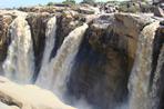
Highlights
The Augrabies Falls waterfall and the adjoining ravine are considered one of the most spectacular sights in South Africa and is a highly recommended destination. Located in an arid-area, the reserve offers spectacular scenery and is one of the best locations in South Africa to view Klipspringer and Dassies (Rock Hyrax). The nature reserve is not only about the waterfall and visitors should take time to explore the surrounding area as well. The Klipspringer Hiking trail is a 3 day, 2 night hiking trail that leads one further into the reserve, providing an excellent overview of the landscape.
Activities
There are a number of observation points near to the waterfall from which visitors can enjoy spectacular views of the waterfall. The game viewing road network allows visitors to explore the reserve and enjoy sightings of the 48 different mammal species found here, including Springbok, Red Hartebeest, Greater Kudu and Giraffe. Steenbok are also common along the open sand-flats and Klipspringer are regularly seen in the rocky areas.
The Dassie Nature Trail is a 5 kilometre (3.1 miles) self-guided hiking trail that leads one on a circular route along the gorge to Arrow Point and then out across the landscape before returning to the camp. There is also a 3 day hiking trail, known as the Klipspringer Hiking Trail, which visitors can pre-book to go on.
Park-run activities include, guided game-viewing night drives as well as the Gariep 3-in-1 Adventure activity that takes one on a 3 kilometre (1.86 miles) canoe ride on the Orange River, followed by a 4 kilometre (2.48 miles) hike and an 11 kilometre (6.82 miles) mountain bike ride. The 94 kilometre (58.2 miles) Wilderness Road is a 6 hour long 4X4 trail with a scenic picnic spot along the way and braai (barbeque) facilities.
Accommodation
There are 59 chalets and bungalows available as Augrabies Falls accommodation, as well as caravan and camping facilities.
The Experience
Aside from the beautiful scenery and breath-taking natural splendour of the Augrabies Falls, the Augrabies Falls National Park offers a well-priced restaurant and comfortable accommodation. The game drive does not provide sighting of abundant game, but is still recommended as a way of getting a bigger overview of the reserve and its landscape. The walkways and viewpoints are occasionally damaged from water and visitors are advised to be cautious and not allow small children to run around too close to the edge.
Climate
The Augrabies Falls National Park is located in an arid area known for extreme temperatures. Day time summer time temperatures are usually around 25°C (77°F) to 27°C (80°F) but have been known to reach a staggering 46°C (115°F) with rock surface temperatures exceeding 70°C (158°F).
Winters on the other hand drop to below freezing. Rainfall occurs in the form of thunderstorms between January and April and the river area above the waterfall is known to periodically flood due to heavy rainfall in the upper catchment area of the Orange River.
Useful Information
While the reserve is not located within a Malaria area, there is a small risk of infection during the summer months. Miggies (gnats) can become a nuisance, especially near the water, however; applying bug spray usually chases them away.
Due to the extreme hot and cold temperatures in summer and winter, the best times to visit the reserve are in autumn and spring when temperatures are milder and more manageable. If you are in the reserve during the extremely hot summer months always remember to carry extra water supplies with you and to wear sun block and a hat.
The rocks and walkways around the ravine are known to be extremely slippery and visitors are advised to exercise extreme caution when viewing the waterfall as deaths have occurred.
 The enigmatic and alluring Augrabies Falls National Park is situated just west of the town of Upington in the Northern Cape Province of Sout...
 Home to one of the world's most spectacular waterfalls, Augrabies Falls National Park is known for its spectacular scenery, and large number...